47-039-05999
Well drilled in 2007
Producing formation(s): Lower Huron Shale, Rhinestreet Shale
Geographic location: latitude 38.53059, longitude -81.748804
Visited in 2009
This recently drilled wellsite is on a ridge above Dry Branch, west of Kelly's Creek Road.
The well access road has a gate at the entrance and is graveled for a short distance. As it climbed the steep hillside, the road grew progressively more rutted and had little vegetation. Sediment traps for culverts were completely filled, so water used the road as a channel.
The pad was sparsely vegetated with large bare areas. The orange plastic fencing for the pit lay to the east, on a log pile. Exposed pit liner was seen west of the well head.
There was no API number as is required, but the condensate storage tank had a proper secondary containment dike. A site of a spill was noticed between the wellhead and the tank. We believe that condensate was spilled during transfer from the tank to a vac truck.

This is a view of the production equipment looking south. The secondary containment dike surrounds the storage tank, separator and other equipment.
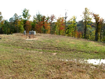
This is a view of the pad, looking south. The wellhead is offset to the east, but is centered from north and south.

The orange plastic fencing used to surround the pit was left on top of a log and brush pile to the east.

This large portion of exposed pit liner was visible to the west of the wellhead. To the south of this spot was a large area bare of vegetation.
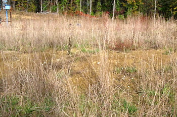
This is the large area bare of vegetation south of the exposed portion of pit liner.
Other bare areas were seen on the opposite side of the wellhead.

This operator installs a ground cable for their condensate storage tanks. If lightening hit a tank that wasn't properly grounded, volatile gases in the headspace would explode, destroying the tank and creating a large spill. Grounding of tanks is not required in West Virginia, but should be.

The well access road climbed a steep slope and was severely rutted. Some of the ruts were quite deep, much deeper than the 2 to 4 inch criteria we use as a signifier of a problem.

Another view of the severely rutted road. Climbing this slope in winter must be difficult.
A major cause of road degradation in this case is due to water using the road as its course, rather than being directed away.

This is one of the filled sediment traps. The culvert is entirely buried. Water is not flowing in the ditches, which don't drain properly, but on the road itself.

In one instance we saw an unplugged culvert. This was toward the bottom of the slope.

The reason the culvert was clear was because water didn't enter the sediment trap. Instead, it appeared that stones had been placed to direct the water flow across the road. The water channel cutting diagonally across the road's surface is evident in this photograph. The culvert's sediment trap is just beyond the stones to the left.
Gas Well Site Visits
Examining Well Sites
How We Examined Well Sites
Environmental Assessment
Table with Links to Wells Visited
47-039-05714 Environmental Assessment
47-079-01492 Environmental Assessment
47-039-02026 Environmental Assessment

Gas Well Study is the examination of natural gas wells in West Virginia.
Underground Injection Control Class 2 Wells
These wells are used either for the disposal of oil and gas liquid waste or for the enhanced recovery of oil or natural gas.
Gas Well Study Site Visits
Annual reports, environmental assessments, and individual well information.
YouTube Videos
Select videos from the Gas Well Study YouTube channel.
What Happened at Fernow
An investigation into what caused the vegetation death in the land application area after landspraying hydraulic fracture flowback waste.
The Spill at Buckeye Creek
An investigation into a spill from a Marcellus well site into Buckeye Creek in Doddridge county.
The Details
Plunger Lift Technology on Gas Wells
Fluids Brought to the Surface during Production
Plugging a Well
How To Read a Lab Report
Information the Completion Report Provides
Casing and Cementing