47-079-01324
Well drilled in 2007
Producing formation(s): Berea Sandstone, Lower Huron and Rhinestreet Shales
Geographic location: latitude 38.520285, longitude -81.837521
Visited in 2013
This is a recently drilled vertical shale gas well in the Amherst Plymouth Wildlife Management Area in Putnam county.The completion report for this well can be downloaded.
The site is poorly vegetated with a long fill slope almost bare of vegetation. We visited sites in the Amherst Plymouth WMA because Google Earth showed a large number of wells with no secondary containment for storage tanks and severe site erosion.

The well access road crosses a stream. The operator uses lengths of pipe laid in the stream bed to keep vehicle tires from actually running on the stream bottom. Vehicles pass from left to right in the photo. A stream access like this helps prevent damage to the stream.
After the stream access the well access road rises until it reaches the pad. The well equipment is clustered at the near end of the long pad.

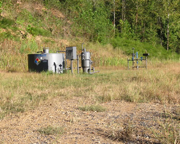
The 50 barrel steel tank does not have the required secondary containment. The separator sits to the left of the tank.
This and another site we visited in the Amherst Plymouth WMA, also without secondary containment, verified what we saw using Google Earth.

At the other end of the pad, where there was little vegetation, there were large and small pieces of pit liner embedded in the gravelly soil.
We tested standing water nearby for chloride and the test showed little or none present.

The pad is almost bare of vegetation.

This is the edge of the fill slope closest to the well access road. The fill slope had very little vegetation.
We didn't go down the fill slope to determine the effects of erosion on the stream below.

This is the 2012 Google Earth view of the well. The well equipment is plainly visible as is the mostly bare site. The fill slope takes up about half of the photo, on the left side. The cut slope, to the right, is also eroded. Water was running across the pad from the cut slope to the fill slope.
Gas Well Site Visits
Examining Well Sites
How We Examined Well Sites
Environmental Assessment
Table with Links to Wells Visited
47-039-05714 Environmental Assessment
47-079-01492 Environmental Assessment
47-039-02026 Environmental Assessment

Gas Well Study is the examination of natural gas wells in West Virginia.
Underground Injection Control Class 2 Wells
These wells are used either for the disposal of oil and gas liquid waste or for the enhanced recovery of oil or natural gas.
Gas Well Study Site Visits
Annual reports, environmental assessments, and individual well information.
YouTube Videos
Select videos from the Gas Well Study YouTube channel.
What Happened at Fernow
An investigation into what caused the vegetation death in the land application area after landspraying hydraulic fracture flowback waste.
The Spill at Buckeye Creek
An investigation into a spill from a Marcellus well site into Buckeye Creek in Doddridge county.
The Details
Plunger Lift Technology on Gas Wells
Fluids Brought to the Surface during Production
Plugging a Well
How To Read a Lab Report
Information the Completion Report Provides
Casing and Cementing