47-097-03707 and 47-097-03708
Well drilled in 2011
Producing formation(s): Marcellus Shale
Geographic location: latitude 38.792995, longitude -80.347727, for 47-097-03707
Visited first in 2012
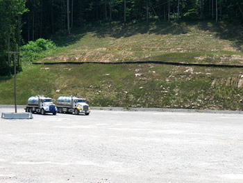
This is the Tall Trees site (named after the surface owner) next to Route 20 in Upshur county. An operator has created a large pad where two horizontal Marcellus wells are located.
Towering over the site is a barely vegetated cut slope bisected by a silt fence. The pad is totally graveled and is surrounded, in parts, by a tall gravel berm. The wellheads are surrounded by fence. Another part of the site holds separators and other equipment and is close to the two tall condensate storage tanks.
A surface owner described how the operator's access road was also the major route of drainage from the site. Heavy trucks and this drainage destroyed the state road used to reach the access road. Because of complaints the operator constructed an armored (graveled) ditch leading to a culvert. There was no sediment control and the water in the sediment basin for the culvert was a bright orange.
The completion report for 47-097-03707 can be downloaded. The completion report for 47-097-03708 also can be downloaded. A copy of the permit application for 47-097-03708 can be downloaded. This permit (and that for 47-097-03707) underwent a number of modifications -- larger pad, longer horizontal laterals, and changed casing programs. The modifications for 47-097-03708 can be downloaded.

This is where the state road meets Route 20. It's not very clear in the photo but the state road's surface is buckled and broken. Repair has been made by adding a top layer of gravel to the paved surface.
The well site entrance is just in back of the photographer.

Turning around 180 degrees, the state road continues to the left and to the right is the entrance to the well site.
The site's access road is gravel, just like the surface of the pad.
The pad is extremely large. A large cut slope rises above one side of the pad.
Two vac trucks are on the left, waiting their turn to fill up with condensate from the large tanks on the site.
We were told the tanks were emptied daily.

The two wellheads are surrounded by fencing and concrete barriers.
The wellheads lie between the well site entrance (off to the right) and the tanks and other equipment (off to the left).

High pressure wellheads are required for horizontal wells.
The wellhead is made up of casing heads stacked one on top of the other with associated valves and pipes.
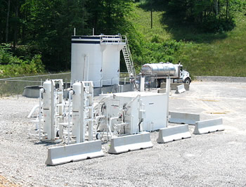
At one corner of the large pad there's a cluster of equipment that appears to be separators and possibly driers for the two wells.
Behind this equipment is the two large tanks holding condensate from the wells.

The two tanks are quite large -- the truck is approximately 10-12 feet high. There are more concrete barriers and fencing. The tanks stand in specially constructed secondary containment formed by pit liner supported along the perimeter by a short metal wall.

The site's drainage exited down the access road to Route 20. Because of complaints, the operator created a large ditch lined with rock to direct the drainage away from the state road/Route 20 and into a large culvert.

The sediment basin for the culvert was filled with bright orange water. There was no sediment barrier between the newly constructed ditch and the culvert.
Visited again in 2013
We revisited this site (the Tall Trees site) as part of the Third Marcellus Academy field trip. The Academy, sponsored by the West Virginia chapter of the Sierra Club, previously had presentations with photographs of the site being constructed, wells being drilled and fractured, and reclamation afterwards. A presentation is available for download. Photographs can be downloaded from links found on this page.
One of the issues we have with this well site is that the location for 97-037o8 is incorrect in the state's databases. That location is over two miles distant from the actual location of the well. The actual location is UTM 17 556630.5E 4293991.9N.
The photographs shown here were taken from a different vantage point than 2012's. These photographs were taken behind and above the large storage tanks.

The two large storage tanks sit within secondary containment. The containment when we visited was more than half full of water. Water in containment displaces spilled tank fluids, making the containment inadequate.

The water in the containment is better seen in this photo.
To the right of the tanks were parts of the well site not easily seen in the 2012 photos.
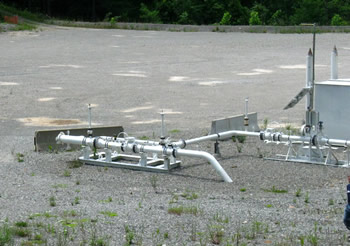
This is part of the pipeline. An apparatus for cleaning pipeline is called a pig. The pipeline feature in the front of the photo has a door for installing a pig.

To the right and behind the pipeline fixtures are two drying units (the boxes). The vertical tanks are either separators or glycol units. Scale of the equipment can be gauged using the walking person in the right foreground.
Gas Well Site Visits
Examining Well Sites
How We Examined Well Sites
Environmental Assessment
Table with Links to Wells Visited
47-039-05714 Environmental Assessment
47-079-01492 Environmental Assessment
47-039-02026 Environmental Assessment

Gas Well Study is the examination of natural gas wells in West Virginia.
Underground Injection Control Class 2 Wells
These wells are used either for the disposal of oil and gas liquid waste or for the enhanced recovery of oil or natural gas.
Gas Well Study Site Visits
Annual reports, environmental assessments, and individual well information.
YouTube Videos
Select videos from the Gas Well Study YouTube channel.
What Happened at Fernow
An investigation into what caused the vegetation death in the land application area after landspraying hydraulic fracture flowback waste.
The Spill at Buckeye Creek
An investigation into a spill from a Marcellus well site into Buckeye Creek in Doddridge county.
The Details
Plunger Lift Technology on Gas Wells
Fluids Brought to the Surface during Production
Plugging a Well
How To Read a Lab Report
Information the Completion Report Provides
Casing and Cementing