47-097-03716
Well drilled and plugged in 2011
Not drilled to a productive formation
Geographic location: latitude 38.849911, longitude -80.309333
Visited in 2012
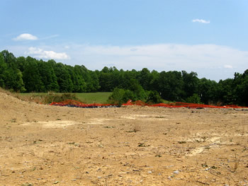
This is a well in Upshur county that was drilled and immediately plugged afterwards. We believe the well was drilled to retain the lease. The well was plugged in May 2011 but when we visited the site in July 2012 the large impoundment and a smaller drill pit were still open. The pad was barely vegetated and a soil sample had a chloride concentration of 384 ppm.
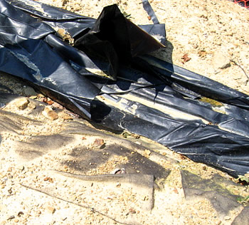
The smaller drill waste pit still had material at the bottom. Large tears in the liner means that this waste is contaminating groundwater.
The plugged well's monument was inappropriate. It consists of a short section of pipe above the ground with a smaller pipe and valved vent. A steel placard has the well's API number.
Final reclamation including filling of the pits, according to law, must follow plugging within 6 months.
A copy of the plugged well affidavit can be downloaded.

There were two pits on the site. One was a large impoundment that probably holds fresh water.
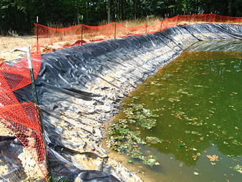
The pit was lined with black liner and had a fence that surrounded most of the pit, except at one corner.
The field next to the site had cow patties in it. There's nothing to prevent a cow, other animal, or person, from falling into a pit if it's not properly fenced.
The liner for both pits was just laid on the surface with no anchor trench to stabilize the liner edges and to prevent it being undercut by rainwater or site drainage.
The impoundment had a geotextile laid down first (the dull black material in the photo) under the liner to help protect the liner from the sharp edges of rocks in the soil.

The drill pit held cuttings and fluid created while drilling the well. The fence was entirely down along the pit's edge.

The pit's liner was badly torn in several places. There still appears to be cuttings/fluid in the bottom of the pit.

The plugged well's monument consisted of a pipe with a cemented smaller pipe with a valve. A steel placard with the well name and API number stands in front.
This isn't a proper monument and a plugged well shouldn't need a vent.
The pad was mostly bare of vegetation. We took a soil sample at one of the light colored spots on the pad and found the chloride to be 384 ppm. Chloride at this concentration will prevent vegetative growth.
Gas Well Site Visits
Examining Well Sites
How We Examined Well Sites
Environmental Assessment
Table with Links to Wells Visited
47-039-05714 Environmental Assessment
47-079-01492 Environmental Assessment
47-039-02026 Environmental Assessment

Gas Well Study is the examination of natural gas wells in West Virginia.
Underground Injection Control Class 2 Wells
These wells are used either for the disposal of oil and gas liquid waste or for the enhanced recovery of oil or natural gas.
Gas Well Study Site Visits
Annual reports, environmental assessments, and individual well information.
YouTube Videos
Select videos from the Gas Well Study YouTube channel.
What Happened at Fernow
An investigation into what caused the vegetation death in the land application area after landspraying hydraulic fracture flowback waste.
The Spill at Buckeye Creek
An investigation into a spill from a Marcellus well site into Buckeye Creek in Doddridge county.
The Details
Plunger Lift Technology on Gas Wells
Fluids Brought to the Surface during Production
Plugging a Well
How To Read a Lab Report
Information the Completion Report Provides
Casing and Cementing