From the Sooytpaws blog
Dozer Tracks
Bulldozer tracking is a recommended process in the Division of Oil and Gas's Erosion and Sediment Control Field Manual which is the guide by which site reclamation takes place after drilling.
We're working on our comments in anticipation to the company's drilling application for our property. There are parts of the Manual that make a great deal of sense, other parts that are confused and obscure and still others that need amendment. Dozer tracking is one.
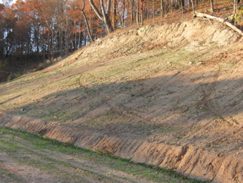
In preparation or seeding, the bulldozer "tracks" up and down slopes to make niches for the seed to sprout in.The problem is that the tracking compacts the heavy clay soil and inhibits more than it promotes growth.
The desired end is at least 70% coverage of grass over the side, quickly, to prevent erosion and there are better ways to achieve this, especially on slopes. They cost a little more.
From what I've seen, companies will spend a fortune carving a site out from a hillside and then drilling a well maybe a mile or more deep. Then they'll start pinching pennies, once it's producing, on reclamation and maintenance of the road and site for the next fifty or more years. It's amazing.
Anyway, a few days ago I got to see a site after seeding where dozer tracking is plainly evident.
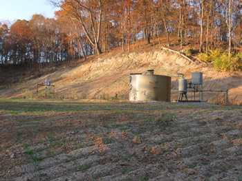
The well is on a large site carved out of a hillside.
The slope above the well is starting to show grass but most of the flat area the well sits on is still bare.
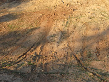
There is no gate or fence and the site is a playground for dirtbikes and ATVs. These are dirtbike tracks on the slope above the well.
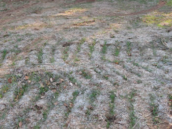
The slopes above and below the well have dozer tracks. The site was hydroseeded but in the end, the seeds settle in the indentations.
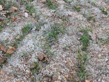
The whitish material is paper pulp mulch which I'm not sure made a difference or not. There is very little sprouting outside of the indentations.
The well had no API number, in with a cluster of others with the same problem. Another, close by, had yet to be seeded. Both wells had other problems and were in noncompliance with regulations (the API number is required), but that's another post.
Posted on Nov. 9th, 2008 at 07:03 pm
Gas Well Site Visits
Examining Well Sites
How We Examined Well Sites
Environmental Assessment
Table with Links to Wells Visited
47-039-05714 Environmental Assessment
47-079-01492 Environmental Assessment
47-039-02026 Environmental Assessment

Gas Well Study is the examination of natural gas wells in West Virginia.
Underground Injection Control Class 2 Wells
These wells are used either for the disposal of oil and gas liquid waste or for the enhanced recovery of oil or natural gas.
Gas Well Study Site Visits
Annual reports, environmental assessments, and individual well information.
YouTube Videos
Select videos from the Gas Well Study YouTube channel.
What Happened at Fernow
An investigation into what caused the vegetation death in the land application area after landspraying hydraulic fracture flowback waste.
The Spill at Buckeye Creek
An investigation into a spill from a Marcellus well site into Buckeye Creek in Doddridge county.
The Details
Plunger Lift Technology on Gas Wells
Fluids Brought to the Surface during Production
Plugging a Well
How To Read a Lab Report
Information the Completion Report Provides
Casing and Cementing