47-079-00731
Well drilled in 1967
Producing formation(s): Lower Weir, Berea Sandstone, Lower Huron Shale, Newburg
Geographic location: latitude 38.471955, longitude -81.750589
Visited first in 2009
This older well is on South Poca River Road between 47-079-00583 and 74-079-01492.
This well is on the flat between 47-079-01492 and the river. At the time we took these photographs (January 2009) the well site was torn up as it was being upgraded along with the drilling and completion of 47-079-01492. Problems at the well were hard to define for that reason.
What we did see was an incorrect API number (wrong county) and industrial debris that should be hauled away when renovation is finished. The extremely large tank had a dike but we didn't measure it. Because of renovation the dike was breached.
When we saw, from a distance, the site November 2008 it was poorly vegetated with large bare spots.
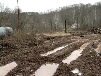
Renovation of the well included replacing some of the pipeline. The horizontal puddles were created by the heavy equipment's weight as it dug the trench to the left.
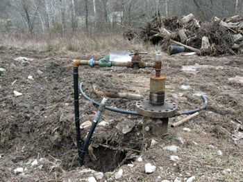
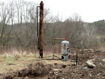
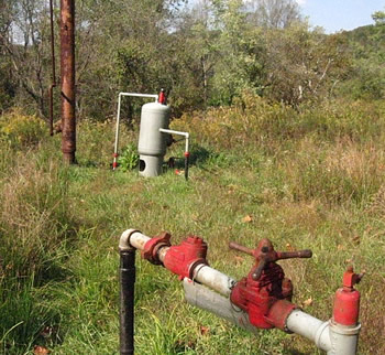
The well is an extremely simple affair.
Plastic pipe was being used to replace the old steel pipeline.
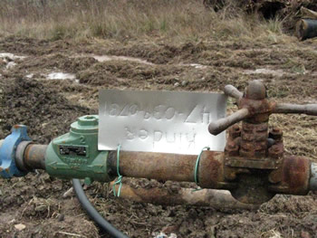
The handmade API sign is attractive but has the wrong county number (039 instead of 079).
There looked to be a fluid leak at the wellhead.
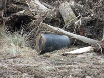
Old 55 gallon drum pushed to the side along with cleared timber.
We've never seen anything before like the tall vertical tank. It's unused. The smaller tank to the right separates condensate from gas.
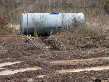
The tank for this well is extremely large. It has a dike which we didn't measure because it was overgrown. A trench was cut throughthe dike during renovation.
Visited again in 2012
This well shares an access road from Poca River Road with 47-079-01492. We visited the site in 2009 and created an environmental assessment for 47-079-01492 and this well.
When we visited this site in 2009 there were deep water-filled ditches and very little vegetation. There was trash on the site, such as old steel drums. The moat type containment for the large 200 barrel condensate storage tank had been breached.
In 2012 the site was well vegetated. There was still assorted trash and the breach in the storage tank's dike had only been partially filled.
This well is located just above the Pocatalico River, separated from the River only by Poca River Road. Drainage from the site reaches the River through two culverts. Because of the site's location and the size of the tank, the breached dike is a federal SPCC violation along with being a violation of state law.
One reason we revisited this site is because the operator did not file production reports for this or any other of their wells for 2008, 2009 and 2010.
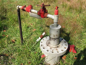
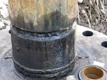
The wellhead has been painted since we visited the site in 2009. What isn't shown in this photo is a hole in the outer casing below the casing head where the casing comes up out of the ground.

The well's API number is incorrect. On the tag it has 47-039-0731 which would place the well in Kanawha rather than Putnam county.
The newer separator is visible just beyond the wellhead, painted like the wellhead in gray and red. The old separator stands to its left. This is amongst the trash we've noted at this site.
Gas Well Site Visits
Examining Well Sites
How We Examined Well Sites
Environmental Assessment
Table with Links to Wells Visited
47-039-05714 Environmental Assessment
47-079-01492 Environmental Assessment
47-039-02026 Environmental Assessment

Gas Well Study is the examination of natural gas wells in West Virginia.
Underground Injection Control Class 2 Wells
These wells are used either for the disposal of oil and gas liquid waste or for the enhanced recovery of oil or natural gas.
Gas Well Study Site Visits
Annual reports, environmental assessments, and individual well information.
YouTube Videos
Select videos from the Gas Well Study YouTube channel.
What Happened at Fernow
An investigation into what caused the vegetation death in the land application area after landspraying hydraulic fracture flowback waste.
The Spill at Buckeye Creek
An investigation into a spill from a Marcellus well site into Buckeye Creek in Doddridge county.
The Details
Plunger Lift Technology on Gas Wells
Fluids Brought to the Surface during Production
Plugging a Well
How To Read a Lab Report
Information the Completion Report Provides
Casing and Cementing