47-079-01178
Well drilled in 1994
Producing formation(s): Lower Huron Shale, Oriskany, Newburg
Geographic location: latitude 38.518842, longitude -81.76499
Visited in 2008
This well is between 47-079-01288 and 47-079-01299, on a separate gated road, down into a hollow. The road itself is a remarkable technical achievement that has been allowed to deteriorate because of lack of maintenance. A special section below is devoted exclusively to this road because it shows the whole range of problems we saw at the sites we examined.
This well has the most beautiful location of all the wells we visited, facing west across the hollow to another ridge.
The well had two minor leaks, a fluid leak at the Christmas tree and a small leak on the wall of the 100-barrel tank. A whittled stick was used to keep a linkage open and this isn't proper maintenance.
The tank had a dike but it isn't large enough for the tank's capacity, nor could we see a rainwater drain.
Vegetation on the site was good on the fill slope, spotty on the pad and inadequate on the cut slope to keep it from slipping. Drainage control and deeper rooted vegetation need to be used on the cut slope.

Deep ruts between main access road and well.
Photos taken along the whole road and commentary are found below.

This drain culvert is supposed to have a flexible culvert attached to the end. The flexible culvert goes down the fill slope. As it is now water falls onto a flat spot on the edge of the fill slope. Eventually there will be problems here.

A linkage at the separator had a specially trimmed piece of wood propping it up. This isn't proper maintenance.

The tank shows signs of leaks starting on the side walls. The dark material is a leak from the interior of the tank.

Leaking gunk at Christmas tree.

The tank has a dike with no rainwater drain that we could see. The dike isn't large enough for a 100-barrel tank; it's 19 by 15 by 2 feet high.

There are a number of slips at this site and road. This slip is one of a band across the top of the cut slope. A ditch or dike above the cut slope needs to be created to keep water off the slope.

The pad vegetation is spotty. This area, near the wellhead, shows signs of an oil spray from the wellhead.
The road for 47-079-1178
The road to this well shows the range of maintenance problems and issues that the operator's well access roads have: poor drainage, serious rutting, lack of maintenance, and bad design.
This was the most complex road we saw constructed by the operator and parts of it are a marvel. On the whole though, either because of bad design or poor maintenance, the road is seriously deteriorating. Repairs will be costly.
Road issues like these don't just effect the operator and the safety of its employees and contractors. They also affect the surface owner on whose property the well lies. A road like this is a slap in the face to someone who has already had to put up with the operator's "taking".

Most of these photos were taken looking east while walking up hill from the well. There is a cut slope on the right hand (south) and fill slope on the left hand. The narrowest point in the road is about 16 feet -- between a rock wall and a tree.
In this photo the ditch to the right isn't working properly. The road should have gravel surfacing. It is deeply rutted.

There are two special fill slope drains. One looks like it is working properly. This one is not. The flexible culvert has broken off the steel culvert that comes from under the road. Water now falls on a level spot. Eventually the fill slope will give way, undermining the road.
We've been told that the culvert has been like this for years.

A cut log and rocks fallen from the hillside blocking a ditch.

The tall fescue seems to clog the ditch.
The ditches need to be cleaned and reshaped and, if major road work is considered, there need to be more culverts installed.
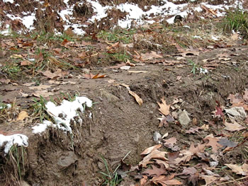
The ruts on this road are very deep in spots. There is no provision for getting water off the road surface by insloping.

A lot of water goes down the hillside at this point and the fill slope has slipped, narrowing the width of the road to just allow a vehicle to not fall off.
Poor ditches, poor drainage -- a muddy, dangerous mess.

The road is so narrow at this point because of the slip that vehicles have to use the ditch as road bed.

Looking back, the slip is plainly obvious on the right.
Water should not be allowed to sit on the road bed. If it is, like here, that is a sign of poor design.

Looking uphill again. On the cut slope side, because of rocks, it is impossible to have a ditch. Instead, water is allowed to course down the road itself, creating problems like we've seen in the previous photographs.
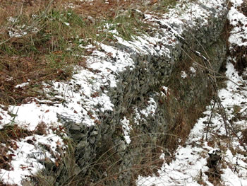
At one point, on the fill slope, a stone wall retaining structure was built. Something like this is what needs to be done where a slip is eroding the road.

Looking downhill, the stone wall retaining structure is in the center of the photo.
The structure is created with stone held by wire fencing.
Gas Well Site Visits
Examining Well Sites
How We Examined Well Sites
Environmental Assessment
Table with Links to Wells Visited
47-039-05714 Environmental Assessment
47-079-01492 Environmental Assessment
47-039-02026 Environmental Assessment

Gas Well Study is the examination of natural gas wells in West Virginia.
Underground Injection Control Class 2 Wells
These wells are used either for the disposal of oil and gas liquid waste or for the enhanced recovery of oil or natural gas.
Gas Well Study Site Visits
Annual reports, environmental assessments, and individual well information.
YouTube Videos
Select videos from the Gas Well Study YouTube channel.
What Happened at Fernow
An investigation into what caused the vegetation death in the land application area after landspraying hydraulic fracture flowback waste.
The Spill at Buckeye Creek
An investigation into a spill from a Marcellus well site into Buckeye Creek in Doddridge county.
The Details
Plunger Lift Technology on Gas Wells
Fluids Brought to the Surface during Production
Plugging a Well
How To Read a Lab Report
Information the Completion Report Provides
Casing and Cementing