47-079-00615
Well drilled in 1956
Producing formation(s): Big Lime
Geographic location: latitude 38.477324, longitude -81.746324
Visited first in 2009
This older well is on South Poca River Road between 47-079-01492 and 47-079-00743.
The well has several problems. There is no API number as required by state code and regulation and the 1,000 gallon plastic tank doesn't have the required secondary containment dike. In addition, there was a gas leak at a union joint both times we visited the site.
The layout is unusual; we've never seen horizontal vessels like those at this site. The metal was well protected by paint and the site was well grassed with minimal ruts in the road (probably due to the presence of a cable gate of the state road). There were a few items of debris -- plastic pipe, old steel pipeline pipe and what looks to be no longer used pipeline equipment to the west of the well.
We know this well is 47-079-00615 by looking at maps at the state's Office of Oil and Gas.
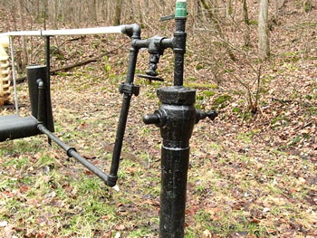
The wellhead has a very simple setup. The lower black pipe goes to the horizontal vessels and then to the pipeline. The white plastic pipe goes to the tank.
The gas leak was at the union joint in the lower black pipe.

Two horizontal vessels are between the wellhead and the tank.
The plastic tank's capacity is 1000 gallons. It doesn't have the required secondary containment dike.

There was a long horizontal vessel and then a short one. We have no idea of their purpose but suspect the tanks collect condensate.

The plastic tank had holes at each end so we were able to look inside. When we were at the site it was empty. There was a valve at the bottom, north end.
We plan to return to this site and test the soil for chloride contamination from the tank.

To the west of the well there was what looked to be unused equipment that was part of the pipeline.
Some sections of the steel pipeline had been replaced with plastic pipe and there were scraps of each on the site.
Visited again in 2012
This well, on south Poca River Road in Putnam county, is considered abandoned by the Office of Oil and Gas. No operator is known. We first visited this site in 2009 when we found gas leaking from a union joint and condensate storage tank without secondary containment. The site is above the Pocatalico River, separated from the river by the road.
We didn't hear a gas leak in 2012 but the tank still doesn't have containment. The tank's open ends allow viewing into the tank. It's apparent from marks on the interior of the tank that it has overflowed in the past.

The condensate storage tank looks like it originally was made to be used as a septic tank. Both the inlet and outlet at the ends are open.
There's no secondary containment as required by state law.

The view inside the tank from the outlet hole. It's possible to see that the tank's liquid level has been as high as the inlet hole on the other side.

This well is the only well where we've seen these horizontal metal tubes. We believe this is part of the separator which removes liquids from the gas.

The well's metalwork has been painted but even so there are signs of severe corrosion
Visited in 2013
This is a producing abandoned well (the state doesn't have the name of an operator). We visited the site in 2009 and again in 2012. We revisited the site in 2013 as part of the 2013 Gas Well Workshop fieldtrip. The photographs shown here were taken in 2009 and 2012.
This was one of the wells that the Office investigated after our 2012 Gas Well Study.

This is an older vertical well. The wellhead is in the foreground. There is no API number on the well.
The plastic tank is in the background. Between the tank and the wellhead are two long horizontal tanks. We believe these are separators.

The Office's report called this a double walled tank, meaning the tank has two walls and doesn't require secondary containment.
The tank in actuality appears to be a reused septic tank and only has a single wall.
The tank is too small to fall under federal SPCC requirements.

The valve at the bottom of the tank was dripping when we were on the site in 2013. We took a soil sample and tested it for chloride. The soil sample showed chloride at >641 ppm (the upper limit of our test method).
This wet area drains from the tank toward the bank above the road by the Pocatalico River.
Gas Well Site Visits
Examining Well Sites
How We Examined Well Sites
Environmental Assessment
Table with Links to Wells Visited
47-039-05714 Environmental Assessment
47-079-01492 Environmental Assessment
47-039-02026 Environmental Assessment

Gas Well Study is the examination of natural gas wells in West Virginia.
Underground Injection Control Class 2 Wells
These wells are used either for the disposal of oil and gas liquid waste or for the enhanced recovery of oil or natural gas.
Gas Well Study Site Visits
Annual reports, environmental assessments, and individual well information.
YouTube Videos
Select videos from the Gas Well Study YouTube channel.
What Happened at Fernow
An investigation into what caused the vegetation death in the land application area after landspraying hydraulic fracture flowback waste.
The Spill at Buckeye Creek
An investigation into a spill from a Marcellus well site into Buckeye Creek in Doddridge county.
The Details
Plunger Lift Technology on Gas Wells
Fluids Brought to the Surface during Production
Plugging a Well
How To Read a Lab Report
Information the Completion Report Provides
Casing and Cementing