47-079-01363
Well drilled in 2007
Producing formation(s): Lower Huron and Rhinestreet Shales
Geographic location: latitude 38.490566, longitude -81.767081
Visited first in 2008
This well is part of a cluster of wells at the southern end of the long main well access road. This is the fourth, just after 47-079-01155.
This is a newer site that when we visited still had the gray-white paper pulp mulch visible. The site had recently been seeded but germination on the pad was spotty, nonexistent where driven over. An entry on our blog deals with the bulldozer tracking we saw at this site.
The 50-barrel steel tank is heavily corroded in spots with quarter-sized blisters. The tank doesn't have the required secondary containment dike.
Trash was present at the site on the newly seeded pad and also as pieces of black plastic culvert tossed down the hillside. The one culvert had its inlet end smashed by machinery and no sedimentation control on the outlet end.
The access roads here as elsewhere in the area were in need of maintenance.
An API number is required by the state to be displayed at a well but no tag was on the well.

Vegetation was extremely spotty on the pad, absent where vehicles frequently drove.

The cut slope above the well site doesn't show signs of much grass germination.

The inlet end of a culvert has been smashed by equipment.

There is no sedimentation control on the outlet side of the culvert. Until vegetation is established, temporary sedimentation control is required.

The tank showed severe rust blistering. The surface needs to be scraped and painted.
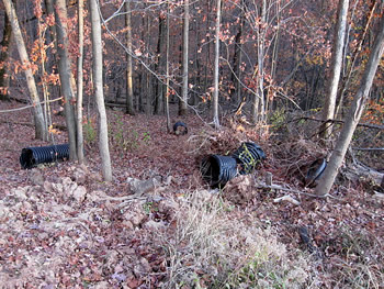
Scrap pieces of culvert were tossed down the hillside. They should be gathered and disposed of properly.

On the well pad was this scrap plastic that looks like it is a pipe thread protector.
The poor germination on the pad is evident in this photo.

A large piece of plastic left on the well pad.

The tank is without required secondary containment.
Visited again in 2010
The site at first glance looked essentially the same as in 2008. The attempt at seeding the site had not been very effective. The tank did have required secondary containment now. The wellhead still did not have the required API number.

The most heavily vegetated area on the pad surrounded the production equipment.

The rusted wellhead we saw in 2008 had been repainted.

Even in the vegetated portion of the pad the vegetation was sparse.

The storage tank which was had been showing signs of severe corrosion in 2008 showed more extreme signs of serious corrosion.
Gas Well Site Visits
Examining Well Sites
How We Examined Well Sites
Environmental Assessment
Table with Links to Wells Visited
47-039-05714 Environmental Assessment
47-079-01492 Environmental Assessment
47-039-02026 Environmental Assessment

Gas Well Study is the examination of natural gas wells in West Virginia.
Underground Injection Control Class 2 Wells
These wells are used either for the disposal of oil and gas liquid waste or for the enhanced recovery of oil or natural gas.
Gas Well Study Site Visits
Annual reports, environmental assessments, and individual well information.
YouTube Videos
Select videos from the Gas Well Study YouTube channel.
What Happened at Fernow
An investigation into what caused the vegetation death in the land application area after landspraying hydraulic fracture flowback waste.
The Spill at Buckeye Creek
An investigation into a spill from a Marcellus well site into Buckeye Creek in Doddridge county.
The Details
Plunger Lift Technology on Gas Wells
Fluids Brought to the Surface during Production
Plugging a Well
How To Read a Lab Report
Information the Completion Report Provides
Casing and Cementing