47-079-01492, part 2
This continues our examination of this well site. The previous section is here.
Visited April 2009
We visited this site in April 2009 after there had been heavy rains but the ground had had some time to dry a little.
We began our environmental assessment for these wells (47-079-01492 and 47-979-00731) by examining the site more closely -- not just looking at the wells. We also went off the pad to the east where we found an abandoned piece of production equipment and a monument for a plugged well (47-079-00595).
We found an area with a large number of deer tracks just to the north of 47-079-00731, where the surface water from the site runs off the pad, down a hillside to the river. South of the deer tracked area, at the large pile of cut logs and timber at the toe of the fill slope for 47-079-01492, we heard a loud bubbling sound from the ground, smelled condensate (a sharp, acrid oily odor), and saw signs of oil on the water (sheen). We believed there was either a pipeline leak at this point or, equally likely, there has been a blow out during the drilling or completion of 47-079-01492.
This and other problems we noted at these wells were included in a complaint made to the state in mid-April. What turned out to be a pipeline leak was repaired, but none of the other issues had been addressed.
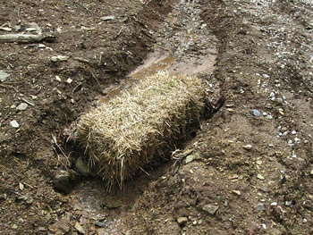
On earlier visits we had noted sedimentation control problems (i.e., lack of effective sedimentation control). New bales of straw were added in February 2009 but were inappropriately installed as before. This bale is installed sideways in a ditch, allowing sediment to flow around it.
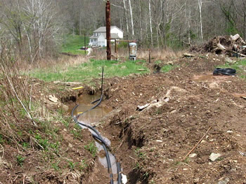
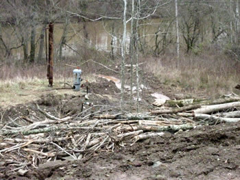
Deep trenches had been dug between our November and January visits and were still open. The trenches were for pipework for both 47-079-00731 and 47-079-01492 to connect them to the tank and pipeline. Plastic pipe was being used.
There was a fair amount of trash strewn about the site. This example was near the edge of the closed pit. Plastic (pit liner?), drink bottles and other trash are easily visible in this photo.
This is a photograph of the spot with a large number of deer tracks. The site is open and there is lots of water available elsewhere. Our assumption was that there was high chlorides here.
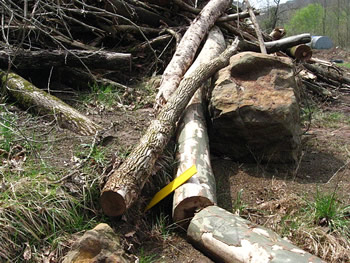
The pipeline break was under this pile of timber. There were pieces of pipeline markers at the west and east end of the spot where we heard and smelled the condensate and gas leaking through the soil. This is the eastern piece of pipeline marker. We went further east and saw no pipeline markers and it was possible that these pieces of markers came from elsewhere on the site.
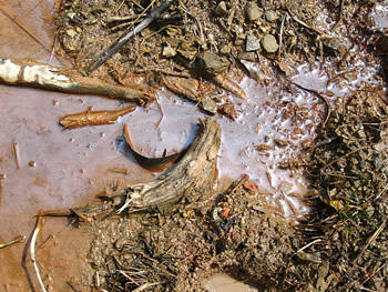
There was an oil sheen to the water on the site where we could smell and hear the seeping gas and condensate.
North of this area is where water drains from the site down a hillside into the Pocatalico River.
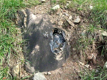
North of the wellhead for 47-079-01492 is the closed drill pit. The state didn't (and still doesn't) have explicit requirements for how a pit is to be closed. We believe 3 feet of soil should be used as cover and the surface contoured so there is no ponding of water.
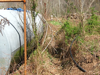
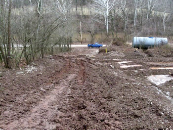
The extremely large tank holds 200 barrels, over 8,000 gallons of condensate (crude oil and brine). The tank has an adequate secondary containment using a moat-type dike. The dike, though, had a trench through it for more than a year.
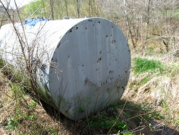
The tank rests on a soil pillar which is why this is a moat-type dike.
There is no rainwater drain.
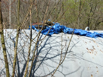
The trapdoor for the tank is either missing or badly corroded. There was a piece of blue tarp held down by a stone on the lid.
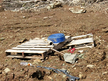
The cast off piece of production equipment east of 47-079-00731 was tipped over and had a tree fallen across it. It had obviously been here for some time.
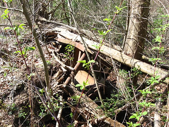
The equipment is about 8 feet long, made of steel with a tank or body and large pipes coming out the top. It's barely visible here amidst all the vegetation that's grown around it.
We returned to the site again in June and tested soil and water for chlorides. We found that contaminated water was leaving the pit, draining down the fill slope and eventually entering the Pocatalico River.
Visited summer 2009
In June we tested soil and water on and around the site for chloride. We found that water was entering the closed pit, contamination was draining down the fill slope and through a log and brush sediment barrier. After leaving the barrier the water drained past the older well (47-079-00731) and eventually entered the Pocatalico River. An Environmental Assessment is available.
A description of our process for testing for chlorides has some photographs taken during our June 2009 visits.
This is an extremely complex site and this page will only offer photographs and a short narrative compared to what appears in the Environmental Assessment.
This is a reduced version of the map that appears in the Environmental Assessment which shows the layout of the site and the locations where water and soil samples (a total of 30) were taken.
Sample numbers are shown in pink for concentrations of less than 30 parts per million (ppm) for chloride. Red numbers show locations where samples were between 30 and 499 ppm for chloride. Underlined red numbers show locations where chloride concentrations were above 500 ppm.
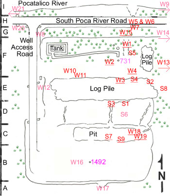
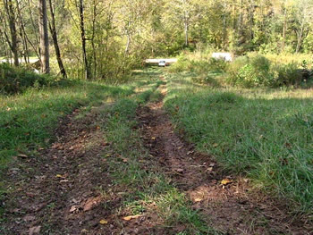
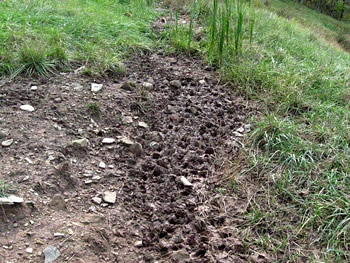
At the western side of the site is the well access road for 47-079-01492 and 47-079-00731. This extremely steep road only had a short section of gravel at the entrance. There was no attempt to control sediment leaving the site and entering the Pocatalico River (just beyond the blue truck in the background).
The large blue condensate storage tank had an adequate secondary containment dike, but the operator breached the dike (the trench is visible in this photo) and left the containment like this for at least half a year. Because of the location of the tank above the Pocatalico River and its size, this is a clear violation of Federal law.
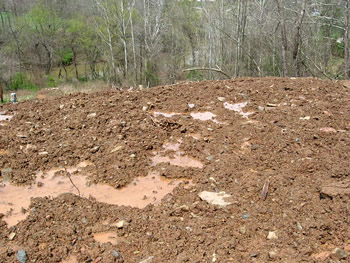
This photograph was taken in January 2009 of the pit, looking east. Between our visit in November and when this photograph was taken several slips had occurred. Most of the cut slope slipped toward the pad and a slip of the fill slope bisected the pit as seen here. The northern edge of the pit is several feet below the elevation of the southern edge and the existing freeboard is less than a foot. We did not observe tears in the liner (the black plastic in the photo). At this time the orange fencing surrounding the pit was down.
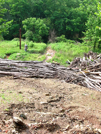
This photograph was taken in June of the slipped area of the pit looking in the same direction as the previous photograph. There is ponded water at this location though we never saw water crossing the pad to here. We did observe water running down the fill slope from the pit area. It was this water that carried contaminants across the site from the pit.
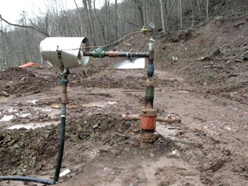
The wellhead for 47-079-01492 is a simple affair. The operator used plastic pipe to connect the wellhead to the pipeline.
This photograph was taken on the pit's edge looking north across the site. The log barrier is below, a ditch with water is to the east of 47-079-00731 (barely visible in this photograph) and the separator (the gray tank). This ditch was the primary avenue for water and contaminants leaving the site.
This is the same view, taken in June standing at the eastern edge of the pit and shows how verdant this location is. The river is obscured by the leafed out trees.
The log sediment barrier in the foreground was at least 8 feet tall and sediment rose to its full height. The amount of sediment unleashed during construction and drilling of a well is measured in tons. The operator never used a sediment control device between the edge of the site and Poca River Road or between Poca River Road and the River. If this were any other type of construction this would be required by law. The EPA exempted oil and gas from federal regulations, leaving it to the states.
09_sheen.jpg)
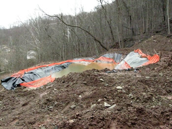
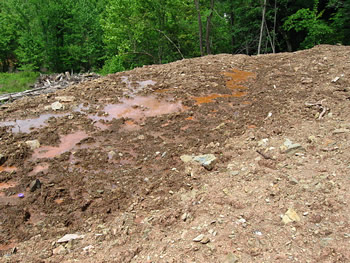
Most of the pollution on the site was invisible except in areas directly affected by the flow of contamination from the pit. Because of the colors we saw (bright orange water and soil, for instance) we believe there was a high iron content. Some bacteria are iron-loving and they create a sheen similar to what is caused by oil on water.
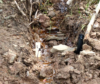
This is the location of sample W3, a water sample taken at the spot of drainage through the log pile toward the pad for 47-079-00731 which sits below 47-079-01492.
This water sample had a chloride concentration greater than 650 mg/l (or parts per million), the upper limit of our test.
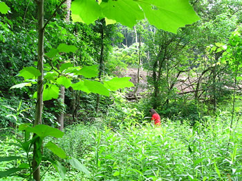
To the east of the well site is a wetland with large areas of standing water. Molly in the red shirt is between where we tested the water here (sample W13) and the fill slope for 47-079-01492. Sample W13 showed a chloride concentration of 57 mg/l. We have never seen uncontaminated water or soil have a chloride concentration above 30 ppm.
To the west of the main flow of contamination from 47-079-01492's pit we found elevated chloride concentrations at two locations on the pad for 47-079-00731, beyond the log pile.
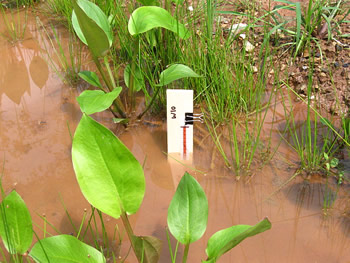
This is the sample location for W10 which found chloride at 113 mg/l.
We saw tadpoles at this spot. The state assumes that concentrations of chloride below 230 ppm are not a danger, in spite of the fact that chloride begins to adversely aquatic species (some plankton) at 12 ppm.
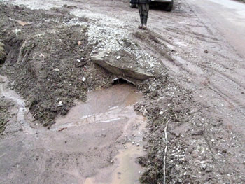
The first photograph of this series shows the steep well access road. This is of the culvert (nearly plugged in January 2009) that passes under the access road (looking west). Poca River Road is just to the right.
It was obvious in January that mud was leaving the site in huge quantities, with no serious attempt at management.
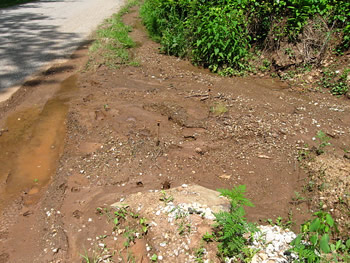
This is the same location but looking east. The operator put three bales of straw in the mud to try to control the sediment entering the culvert. The bales have been entirely covered, the culvert is entirely blocked, and the ditch that we saw in November 2008 to the road and along the road no longer exist because of the volume of sediment leaving the site.
The operator never considered and the state never required a final sediment barrier between the road and the River.
Visited again in 2012
This well shares the same access road as 47-079-00731 and is situated on a bench above the older well. Both wells are above the Pocatalico River.
We first visited both these wells starting in 2008 and created an environmental assessment of the sites in 2009. We found a stream running through the buried pit waste on the pad of 47-079-01492 carrying contaminants (we were measuring chloride) down the fill slope, past 47-079-00731, eventually reaching the River.
Problems we noted in our 2012 visit mirror those we saw in 2009: a poorly vegetated pad, exposed pit waste, and a poorly maintained access road. The access road has a steep grade and is situated so that any sediment washed down the road by rainfall is likely to reach the River.
In 2008 when the well was drilled a slip occurred so that part of the pit located on the fill slope moved downhill. There's been a further slip since we saw the well in 2009 of about 3 feet, cutting through the buried pit waste, exposing pit liner and waste. A small stream still runs through this area.
The completion report for 47-079-01492 can be downloaded.
The access road for this well and 47-079-00731 is off of Poca River Road (visible near the top of the photo -- our car is also barely visible). Just beyond Poca River Road is the Pocatalico River.
The access road is badly rutted. The operator constructed a water bar part way up in 2008/9 but there's been no maintenance and it's cut by ruts now. Sediment leaving this road goes directly into the River.
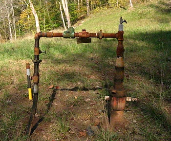
The bare metal wellhead and pipe is rusty.
The pad is poorly vegetated.
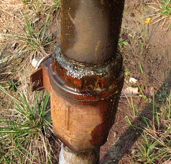
There was oily material leaking out of the production pipe.
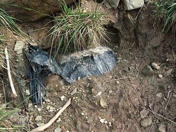
A slip occurred sometime between 2009 when we visited last and 2012. The fill slope slid down about 3 feet, exposing the buried pit waste and liner.
Here's another piece of pit liner exposed by the slip. The pit waste was buried shallowly.
Just to the north of the slip and the exposed pit waste is a large bare area with signs of lots of deer activity.
This is where in 2009 we found high concentrations of chloride in soil and water.
Gas Well Site Visits
Examining Well Sites
How We Examined Well Sites
Environmental Assessment
Table with Links to Wells Visited
47-039-05714 Environmental Assessment
47-079-01492 Environmental Assessment
47-039-02026 Environmental Assessment

Gas Well Study is the examination of natural gas wells in West Virginia.
Underground Injection Control Class 2 Wells
These wells are used either for the disposal of oil and gas liquid waste or for the enhanced recovery of oil or natural gas.
Gas Well Study Site Visits
Annual reports, environmental assessments, and individual well information.
YouTube Videos
Select videos from the Gas Well Study YouTube channel.
What Happened at Fernow
An investigation into what caused the vegetation death in the land application area after landspraying hydraulic fracture flowback waste.
The Spill at Buckeye Creek
An investigation into a spill from a Marcellus well site into Buckeye Creek in Doddridge county.
The Details
Plunger Lift Technology on Gas Wells
Fluids Brought to the Surface during Production
Plugging a Well
How To Read a Lab Report
Information the Completion Report Provides
Casing and Cementing