The Gas Well Road

There’s a natural gas well that’s on the road halfway to our house. The well operator is supposed to maintain their portion of the road but that’s only by guidance. There is no state regulation requiring maintenance. On the whole, well roads that we have seen have been in fair to poor condition. Most of the problems we have seen have been due only partially to design of the road. In most cases the poor state of well roads has been due to lack of maintenance.

That’s the problem with this operator’s section of the road. Their well tender uses the road to access the well at least once a week in a large truck, usually with an ATV sitting in the bed. Several times a year a much larger and heavier vac truck comes to remove fluids from the well’s tank. Other surface owners come out several times a year and we use the road with our ATV and UTV. Our vehicles are lightweight and are designed to do limited damage to a dirt or gravel road.

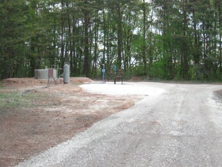
The previous operator in 2010 had a company come in and completely redo the badly deteriorated well road. The “new” road had decent ditches and drainage and a good bed of gravel. The road hasn’t received maintenance since then and it shows with several places having deep ruts (4 to 12 inches deep) and a pothole developing into a gully across the road at the well pad.

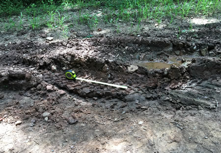
Below I have some photos that contrast the 2010 gas well road and its current condition. In some of the current photographs there’s a tape measure visible. The extended tape is 18 inches long for reference.

View of 2010 work on well road.

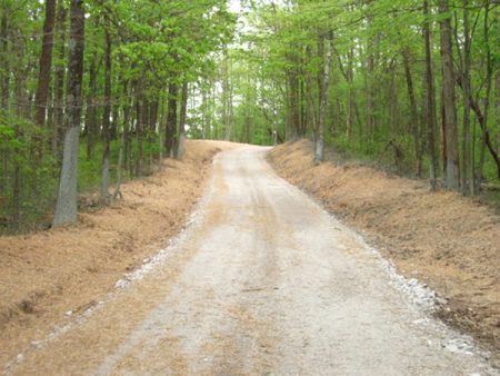
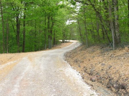
This is a view of the 2010 well road as it goes up a slope and where it turns to the right. Currently, the first bad pothole is on the left side of the road before the turn. It’s about 12 inches deep.

2025 photograph of well road condition.

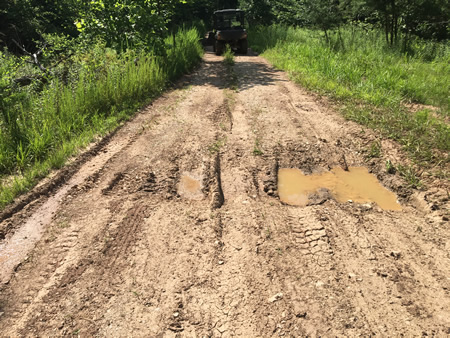
This photograph was taken in August 2025 looking down the slope. The pothole started as a single hole furthest to the edge. Now a second, slightly shallower, pothole has formed toward the center of the road.

2025 photograph showing well road condition.

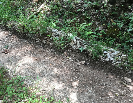
A common problem with gravel roads on clay is that use by heavy trucks compacts the roadbed. In some cases like here, the gravel is pushed upward at the edges blocking rainwater drainage to a ditch. Standing water on a gravel road leads to potholes, ruts, and other problems. The road at this area with the pothole on the edge has gravel pushed up and standing in places up to 12 inches above the road bed.

2025 photograph of well road condition.

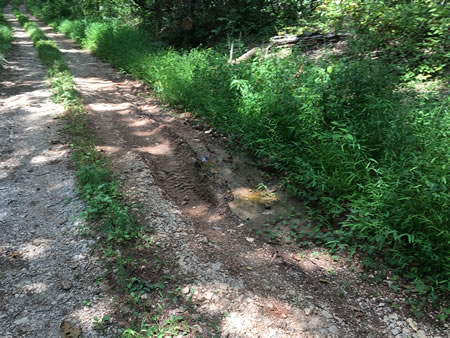
This and the three following photographs show the condition of the road at the turn. The gravel in the foreground was put down at the entrance drive to an owner’s property. The well road has shifted toward the drive as potholes and ruts became worse. The well road bed, as seen in the 2010 photo, is further to the left in this photo and extends into the grass.

2025 photograph of well road condition.

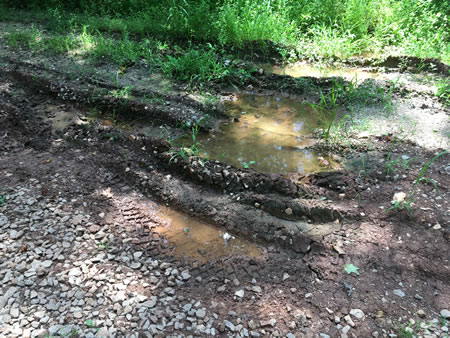
Here is another view of the ruts shown in the previous picture. The ruts toward the top of the photo are the deepest, about 12 inches. It hasn’t rained for weeks and they still hold water.

2025 photograph of well road condition.

With an ATV and UTV we are able to bypass this bad area of the road by running on the uphill side where the neighbor has their drive.

2025 photograph of well road condition.

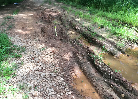
The ruts and potholes extend past the turn.

2010 well road after construction.

This is the 2010 view of the road past the turn.

2010 well road photo showing construction.

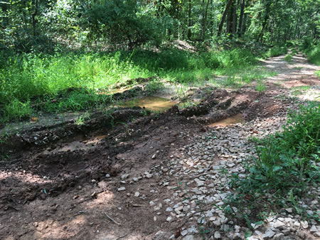
The well pad has always suffered from poor drainage. The current problem on the road at the pad is in the area of the road in the photo about a fourth from the bottom of the frame.

2025 photograph of well road condition.

The 2010 photograph was taken looking south. This photo was taken looking north and shows the gully forming across the road. The deepest rut is about 12 inches. Vehicles currently tend to go partially off the road at the left to miss the deepest ruts. We are able to swerve around the gully to the right with our ATV and UTV.

The well road at this point will be much more expensive for the operator to repair. Periodic maintenance would have taken care of most of the issues seen 15 years after the road was constructed.

History Hidden In Plain Sight

My first impressions of Charleston, West Virginia, in the 1980s were positive. A city with small town feel. There wasn’t an obvious separation of Blacks and whites like I’d experienced where I grew up in St Petersburg, Florida.

Those impressions have pretty much stayed true the years we’ve lived here, not in Charleston but about 25 miles north.

Recently, I’ve been learning about West Virginia’s slavery past, focusing on the area I’m familiar with which was also the area which had the largest concentration of enslaved.

This is a history hidden in plain sight because while a lot of effort seems to have been made to hide the extent of this area’s slavery past, so many roads and places in Charleston are named after the area’s slave masters, Laidley, Summers, Ruffner, Patrick, Littlepage, the list goes on and on.

Slavery in this area had several foci: agricultural, mining, the salt furnaces, and skilled trades such as blacksmith or cooper. Many of the families who settled this area came from eastern Virginia and had owned slaves there. I say many, and while it is true most white families before the Civil War had no property, in 1850 about a fifth of Kanawha county’s population was enslaved.

The economic driver for slavery was salt. Salt came from dug and drilled brine that had to be boiled down before export. These salt furnaces dotted both sides of the Kanawha River below Charleston. Once the easily accessible forest had been cut to fuel the furnaces, coal began to be dug. Many furnaces had their own mines in the ridges above, and coal was also mined in the Saint Albans area and brought by boats on the river to the furnaces which ran continuously.

I’ve been following two families, the Summers, whose house still exists on the Charleston’s West Side, and the Roberts, who owned 750 acres in what is now Cross Lanes. George W Summers owned about 24 enslaved in Kanawha and Putnam counties, and by 1860 Sarah Roberts’ family owned about 15 enslaved.

Amacetta Summers’ letters to George while he was serving in Congress as published, My Dearest Husband: The Letters of Amacetta Laidley Summers 1842-1843, offer insight in the daily life of a fairly well-to-do family in what was then western Virginia. One of the enslaved who is often mentioned is Martha who seemed to be constantly in attendance while Amacetta raised her young son Heber, often quietly sewing nearby.

Martha was purchased by George in 1839 with two other enslaved. Her age was “about 10 or 11.” George’s 1849 will mentions Martha and her son Wesley (one of Amacetta’s concerns in a letter was Martha’s spending so much time late at night attending Methodist meetings). The 1850 federal slave census doesn’t show a young boy owned by George. The slave census isn’t always helpful anyway. While the federal census of free persons lists all the names of people in a household, the slave census lists the enslaved people only by gender, age, and color under the owner’s name. It’s interesting that the during the creation of the census form a deliberate decision was made not to name the enslaved. An 1863 letter to Amacetta by Martha mentions living in Athens (I assume Athens, Ohio, though I haven’t been able to verify that). How and why Martha left the Summers household I haven’t discovered yet. The early 1860s during the Civil War saw a lot of chaos in Charleston as it was taken by one army and retaken by another.

Some of that chaos is mentioned in Nan Stewart’s slave narrative collected during the 1930s. Nan Stewart as a young girl was enslaved by another family near the Summers home, Glenwood. Nan ended up in Ohio after the war, as did one of the Summers’ neighbors, a free Black blacksmith who had moved to Meigs county across the Ohio River and appears in the 1870 census as a resident there.

James Roberts, like the George W Summers’ father, moved to western Virginia from the east in the early 19th century. He purchased 750 acres in what is now Cross Lanes. He died in 1842, leaving a wife and number of children behind. Sarah Roberts appears to have been buried in debt because the 1850 census shows her owning no property. By 1860 one of her sons, Richard, through his hard work and opportunity, had raised the family to moderate wealth and increased the family slave holdings, partly by fathering twin sons, Scott and Taylor, on Sylvia, one his mother’s enslaved, in 1850. He was about 23 and Sylvia was about 17, possibly younger.

Richard’s sons, Scott and Taylor, ended up being owned by his younger brother and sister. The younger brother, Thomas, was a member of the Confederate militia at the beginning of the war, and took Scott along with him as a body servant when Thomas was a Captain in the Confederate army.

Scott and Taylor Brown ended up marrying two daughters of Mary Barnes Cabell (Mary has an interesting story https://www.wvencyclopedia.org/entries/2470 ).

Sarah Roberts seems to have resided in Charleston. Richard’s house in Cross Lanes, located across from the Save-A-Lot grocery store, was torn down in the 1930s.

The published local histories of the area, for some reason, focus on the Confederate militias, such as the Kanawha Riflemen, without mentioning the slave-owning status of militia members. Instead they focus on many members of the Riflemen being lawyers. These militias were soon incorporated in the Confederate Army. George W Summers’ (a lawyer but not a member) son George was a member of the Riflemen and died of measles age 16 as a Confederate soldier.

I’m going to end here and provide some links below for some documents that I’ve found helpful in better understanding slavery’s past.

1839 slave purchase for Martha and two other enslaved: https://hub.catalogit.app/9150/folder/81a914e0-58c8-11ef-a059-c965d223606c/entry/b2d50490-e959-11ee-b1c1-173fac438401

Kanawha county sheriff’s sale of runaway slave (more for showing some of the edifice of slavery): https://rosetta.virginiamemory.com/delivery/DeliveryManagerServlet?dps_pid=IE2562973

Winfield Scott Brown death certificate

1860 federal slave census page showing George W Summers’ enslaved (for Kanawha county; he also owned another 10 enslaved in Putnam county, probably at Walnut Grove, now the location of the John Amos power plant).

1860 federal slave census page showing Sarah Roberts’ and other family members’ enslaved.

1863 letter from Martha to Amacetta Summers. https://hub.catalogit.app/9150/folder/entry/d152eae0-7c43-11ef-87e7-77d2df6e17b2

Photographs of Glenwood and slave quarters in the Library of Congress (the last 3 photographs are of the slave quarters, two other slave quarters buildings no longer exist): https://www.loc.gov/resource/hhh.wv0144.photos?st=gallery

December 12, 1842 letter from Amacetta Summers to George Summers with mention of Martha attending Methodist meetings. From Patricia Clark Bulla, editor. My Dearest Husband: The Letters of Amacetta Laidley Summers to George W. Summers: 1842-1843. University of West Virginia College of Graduate Studies Foundation, Inc., Charleston, WV. No date.

Winter to Spring

This spring was a lot calmer than last year’s. We still had some winter and spring storms, but nothing like the one that hit on April 2, 2024. Work changes during the spring. In March and April, cutting, splitting, and stacking firewood for the season after next takes a great deal of my time and effort. By early May, that work ends and mowing grass begins. Warmer temperatures at night with spring begin the end of our mud season when our dirt roads are a mess.

This photo was taken by Molly the previous firewood cutting season. The large red oak had been severely damaged in a windstorm in early 2023 and I felled it. I’m standing behind the trunk of the tree, which makes it seem much larger than the 24 inches diameter at chest height. I didn’t fell any trees in the 2024-2025 firewood cutting season. The April 2nd windstorm had already done that.

I took this photograph after a winter storm, which left a layer of ice on all the trees. I’m not sure it is possible to catch the way light glimmers on the ice-covered branches.

A close-up of the same photograph.

This photograph was taken from our yard looking west on April 18th. Some trees are starting to show a little green

Redbud trees blooming behind a solar panel array.

A close-up of the flowers of the redbud tree. Spring has really started to arrive.

The same view looking west as the previous photograph, this was taken May 5. The transition from brown to green woods is almost complete. I’m done cutting firewood.